
Discover Historic Mount Pleasant
.jpg)
Gardens at Mount Pleasant Reserve beyond Sunnyside Woollen Mill c1907 (Source: State Library of Victoria)
Explore the oldest residential suburb of Ballarat
The Mount Pleasant History Group in partnership with Ballarat and East Ballarat Neighbourhood Centres, supported by the City of Ballarat, have teased out some of Mount Pleasant's stories for a new heritage trail, Discover Historic Mount Pleasant. Starting at Mount Pleasant Reserve, the trail explores the lives of some of Ballarat's oldest residential suburb's most memorable people and places from the 1850s up to the present, including an overview of its colourful history.
Download the Overiew of Mount Pleasant's History PDF
Stopping Points
.jpg)
1. Mount Pleasant Reserve, Barkly Street
.jpg)
2. Tent school tree, corner Morton & Barkly Streets
Historic Elm tree in 2018 (Source: Leahna Mayo)
More about the tent school and Charles Phillips PDF
.jpg)
3. Sunnyside Woollen Mills, Humffray Street South
In 1872 land at Sunny Corner being used as market gardens was bought by the newly-formed Ballarat Woollen Co. Financed locally as profits from gold were declining, the mill began a new era in Ballarat industry. The architect was Henry Richards Caselli, Ballarat’s most significant historical architect. In 1874 the building was extended and the Romanesque arched section was added in 1886. Production of flannels, tweeds and blankets commenced in 1873. By 1875 the mill employed 150 skilled workers on steam-driven looms. It was described as the most perfect mill of its kind in the southern hemisphere. Following a vice-regal visit in 1895 the re-named Sunnyside Mills became a major tourist attraction. During WW1, still surrounded by Chinese market gardens, it became a major supplier to the Australian military employing 500 people at its peak. An avenue of honour commemorating employees who served in the war was planted in Hill Street in 1918. The mill closed in 1981 as a result of the removal of protective tariffs. Subsequently it was used mainly for warehousing and job training.
Sunnyside Woollen Mill c1895-1900 (Source: H. Hodgson, State Library of Victoria)
4. Yarrowee River & Hill Street Bridge
%20%20.jpg) While technically a river, the Yarrowee is locally known as ‘the creek’. In the long period of Wadawurrung occupation, its waterholes and swamps provided fish, duck, and eels. The water was then clear as it meandered through the valley. From 1837, pastoralists took its water for their sheep and from the mid-1850s miners turned it to mud as the whole valley was sluiced and dredged. From 1873, the woollen mill used the water for scouring and to dispose of toxic residues from dyeing. Several tanneries also discharged poison into it. For decades the Yarrowee was the main drain for Ballarat’s streets and domestic and industrial waste. Even so, the market gardeners who lined the banks continued to grow the vegetables that fed Ballarat, and local dairy farmers watered their cows at the creek. In 1887, the Health officer declared “I would prefer to be without milk than have it from cows drinking such a liquid”. Raging floods washed away bridges, fences and gardens until the deceptively quiet Yarrowee was tamed by the channelling which by 1916 reached the woollen mill, from behind which it still flows freely. After all of this interference, the original course has been lost. For the first thirty years of the suburb’s life the little Sunny Corner footbridge was the only way across the creek at Hill St. A cart bridge with three spans was built in 1886. The present single-span bridge with a reinforced concrete deck is the result of a realignment in 1916.
While technically a river, the Yarrowee is locally known as ‘the creek’. In the long period of Wadawurrung occupation, its waterholes and swamps provided fish, duck, and eels. The water was then clear as it meandered through the valley. From 1837, pastoralists took its water for their sheep and from the mid-1850s miners turned it to mud as the whole valley was sluiced and dredged. From 1873, the woollen mill used the water for scouring and to dispose of toxic residues from dyeing. Several tanneries also discharged poison into it. For decades the Yarrowee was the main drain for Ballarat’s streets and domestic and industrial waste. Even so, the market gardeners who lined the banks continued to grow the vegetables that fed Ballarat, and local dairy farmers watered their cows at the creek. In 1887, the Health officer declared “I would prefer to be without milk than have it from cows drinking such a liquid”. Raging floods washed away bridges, fences and gardens until the deceptively quiet Yarrowee was tamed by the channelling which by 1916 reached the woollen mill, from behind which it still flows freely. After all of this interference, the original course has been lost. For the first thirty years of the suburb’s life the little Sunny Corner footbridge was the only way across the creek at Hill St. A cart bridge with three spans was built in 1886. The present single-span bridge with a reinforced concrete deck is the result of a realignment in 1916.
Gouged bed of the Yarrowee River in 1888 (Source: Fred Kruger, State Library of Victoria)
%20(1).jpg)
5. Chinese market gardens, off Hill Street behind woollen mill
From this spot you can see the rich land of the floodplain of the Yarrowee. From Humffray Street to the banks of the creek there were neat rows of cabbages, cauliflowers, carrots, beans and lettuces. Market gardens ran all along the crown land beside the Yarrowee from White Flat to the other side of the Prest Street bridge. Wild floods would wash away bridges, wipe out the gardens and fill the creek with produce. Sitting in the gardens were the huts of the mainly Chinese licensees who supplied much of Ballarat’s vegetables into the 20th century. Until about 1960 the last market garden in Mount Pleasant was hidden here behind the mill. Ah Lok, also known as ‘Paul the Chinaman’, lived in a pretty vine-covered hut in the midst of his garden. He delivered door-to-door around the suburb with a horse and cart.
Chinese market gardens with Sunnyside Woollen Mill in the background, 1921 (Source: Art Gallery of Ballarat)
.jpg)
6. Prest Street Bridge Precinct
In 1856 John Prest opened the Mount Pleasant Hotel roughly on the site of the former Oliver’s footwear factory. Also near the bridge were Samuel Elstone’s general store and the Red Lion store. Prest was also the first postmaster and the hotel was used for public meetings and coronial inquests. For some years this was the commercial heart of Mount Pleasant. A wooden bridge was built here in 1859. It was first known as the Mount Pleasant bridge and later as the Band and Albion bridge or the Redan bridge. As the boundary between the municipalities of Ballarat East and Ballarat West ran down the middle of the Yarrowee, there was constant bickering as to which council should pay how much for its upkeep. As a consequence, for decades the bridge and its approaches regularly fell into serious disrepair until the present bluestone bridge was opened in 1897. In 1887 the Swenson family established the Surrey Tannery on Tannery Lane. A quarry operated just behind the site of Prest’s hotel. In 1956 Hungarian migrant Alex Suvoltos established a new tannery in the former plaster works opposite the Caltex service station on the corner site. The corrugated iron remnant of another long-running tannery—Nathaniel Martin’s—can be seen in the wrecker’s yard further along Humffray Street at the bottom of Morton Street.
Swensons Tannery and Mount Pleasant Hotel behind (Source: Historical Collection Federation University)
.jpg)
7. Yuille Woolshed site & Miner's Right diggings
Near the end of Greene Drive, at the end of Humffray Street South, is the approximate site of what was probably the first solid European structure in the Ballarat area. It was a woolshed built in 1837. Arthur Yuille also built a small homestead on the opposite side of the Yarrowee. In 1856 the rush to Miner’s Right spread south from the Prest Street Bridge area to Magpie. Just across the creek at the top of the rise is Withers view of ‘old Ballarat’.
Sketch of Yuille homestead in 1847 (Source: Archibald Campbell, National Library of Australia)
.jpg)
8. Former Methodist/Uniting Church, Morton Street
An 1857 sketch of the early Wesleyan chapel on the site, made from canvas tents (Source: Trevor Peers)
More about the former Methodist/Uniting Church PDF
.jpg)
9. Tram terminus & shops, corner Barkly & Cobden Streets
Shops appeared at this corner in the 1880s and from when it became the tram terminus in 1906 it became the heart of Mount Pleasant. The corner was the place where the community interacted daily, in the shops and under the verandahs. Here was the post office and the only public telephone. Shopkeepers lived next door to their shops and employed local people, often for many years. They knew the financial status of everyone in the suburb, extended credit, and in hard times recognised that some were too poor to pay. The building on the north-east corner, now a hairdresser’s, began as Edward Mares’ butchery in the 1880s, became Kilby’s barbershop and when Reg Bartle bought it in 1927 a greengrocers. The Bartle family ran the shop—which expanded with groceries, sub-newsagency, fancy goods, and even a penny library—until 1958. Next door Tom Hill the boot repairer rented his tiny premises (now gone) from the Bartles for 5 shillings a week. He made a better living on the side as an SP bookie. The shop on the south-east corner was built in 1934 by the butcher Jack Hobill when his premises around the corner in Cobden Street burned down. The business on the south-west corner began as Mrs White’s grocery in 1907 and she added the post office in 1912. In 1958 Bill Rees made it one of Ballarat’s first cash-and-carry stores. It has also been a milk bar and a fish and chips shop. The premises a few doors down Barkly Street was Watkins Cakes from 1948-62. Mr Watkins, who worked for Davis the baker, died after being kicked by one of the cart horses, leaving behind a wife with two small children. Davis put the widow into the shop. By the 1980s these shops had been closed or re-purposed. For many years the tram was the main means of transport into town and to distant parts of the city. It was a slow trip owing to the use of loops on the single line. But at 4d (2d for children) it was very cheap. The last Mt Pleasant tram ran on Sunday 5th September 1971.
Mount Pleasant tram terminus c1960s (Source: Ballarat Tramway Museum)
.jpg)
10. Mrs Taylor's lolly shop, corner Tress & Cobden Streets
The Tretheway family had a general store here from 1897. In the early-1940s, Mabel Taylor ran a tuckshop from a window in the house, opposite what was then the school gate.
The former lolly shop, now a private residence (Source: Leahna Mayo)
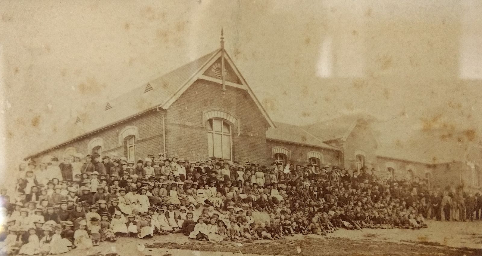
11. Mount Pleasant Primary School, 401 Cobden Street
This was the first State School built in Ballarat. State School No. 1436 was officially opened on August 3, 1874. Designed by Henry Bastow, the State Architect, and built by Llewellyn and Edwards at a cost of nearly £8000 it was a monument to free, secular and compulsory education in the colony of Victoria. More than 500 pupils could be squeezed into the original six class rooms. The land had previously been a dairy farm, and before that was mined for gold—the rich Milkmaids lead ran down the northern boundary. The school is the direct descendent of the 1855 Wesleyan tent school (see 2.). A plaque and photographs inside the building celebrate the achievements of the first head teacher, William Nicholls, who established night classes that allowed more than a hundred mature-age students to matriculate directly from this school. The 1918 Honour Board may also be viewed with the names of forty-eight former pupils who died, and 220 who served in the Great War. The displays may be viewed with permission from the school office. From 1934 to 1958 a Rural Training School was conducted in a separate classroom modelled on a one-teacher country school. In the 1990s, due to the determination of the staff and the community, the school survived a rationalisation process under which many State schools were closed.
Students gathered at the front of the shool for its formal opening in 1874 (Source: Mount Pleasant Primary School)
More about Mount Pleasant Primary School PDF
12. Peady Street Reserve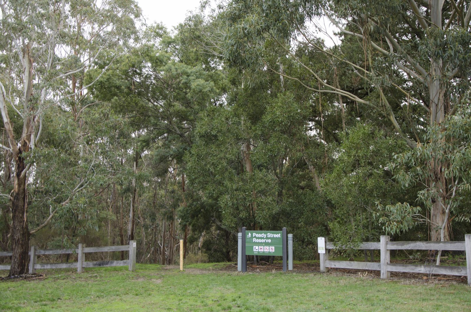
This pleasant winding walk between Trethowan Street and Cobden Street (just up the hill from the school) is on the line of the Milkmaid Lead and shows signs of mining. In the 1980s the bush landscape was preserved by community action to become an accessible experience of the gullies in which generations of local children played. A more extensive remnant gold mining landscape can be found in the pine plantations on the eastern side of Brittain Street.
(Source: Leahna Mayo)
.jpg) 13. Ballarat Municipal Observatory & Museum, 439 Cobden Street
13. Ballarat Municipal Observatory & Museum, 439 Cobden Street
In 1885, the School of Mines was granted three acres to establish an observatory at Mount Pleasant. Captain Henry Baker single-handedly constructed a 12.5 inch (31.75 cms) Newtonian reflector telescope on site. This involved setting up a small foundry to cast parts and hand-grinding the mirror. When it was installed in 1886 Baker was appointed the first curator. A cottage, now gone, was provided for the curator’s family. After Baker died in 1891, the observatory went into decline until it was resurrected in 1913 by John Brittain, a lecturer in astronomy at the School of Mines. He became the curator in 1915 and the Brittain family lived at the Observatory for the next thirty years. From 1890 to 1957 the observatory provided Ballarat’s daily meteorological reports. In 1958, the observatory was saved from demolition by the formation of the Ballarat Astronomical Society. It houses historical working telescopes and a number of remarkable stained-glass windows which can be viewed with permission.
The 198 Jelbart building (Source: Historical Collection Federation University)
Visit the Observatory website
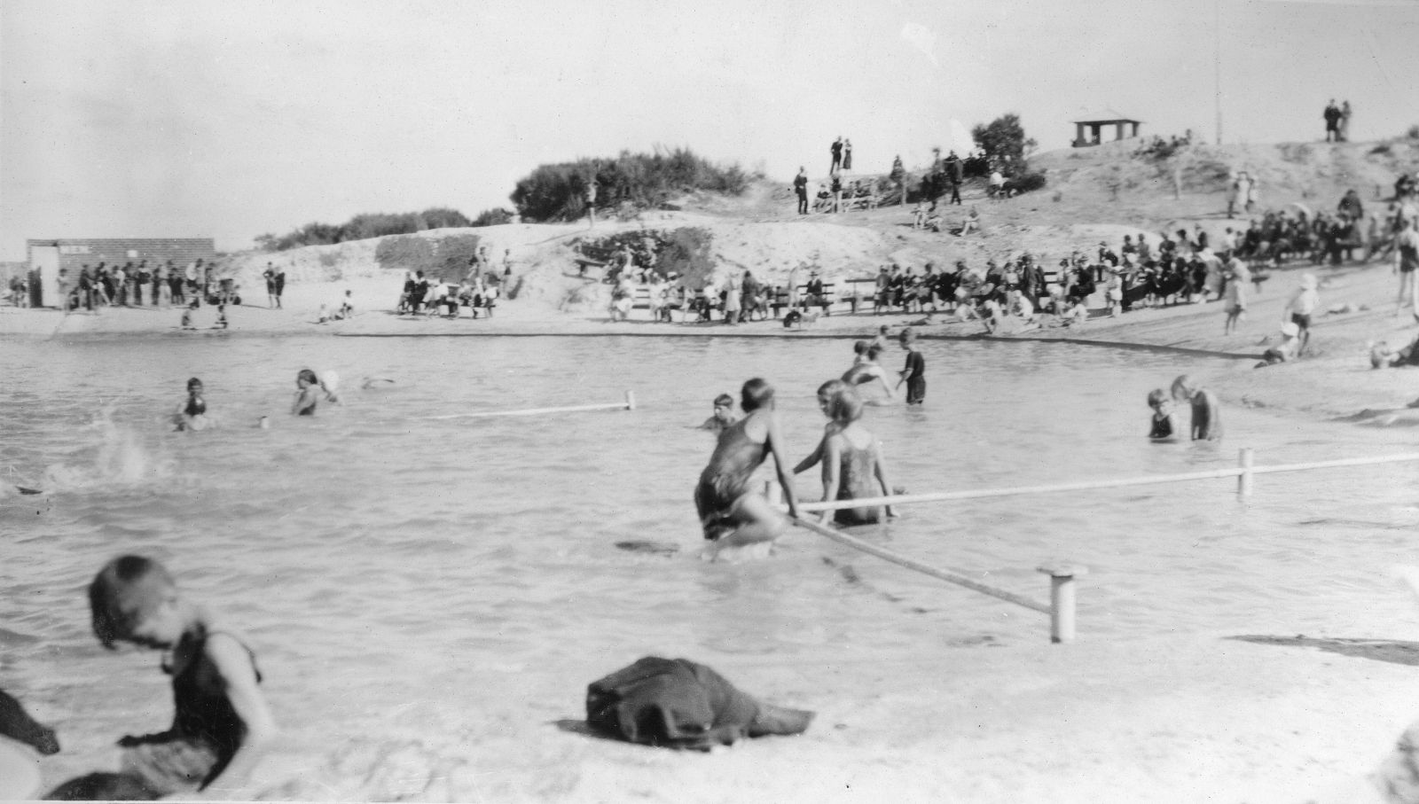 14. Former Swimming Pool & lookout, off Magpie Street
Inspired by The Herald's 'Learn-to-Swim' campaign, working-bees quickly turned an old mining sludge dam into a swimming pool. Opened in December 1930 and known variously as the Golden Mount Swimming Pool and the Sovereign Hill Swimming Pool, this was the local swimming spot for Mount Pleasant residents. Spectacularly located, the large round pool sat just below the gold mines indicator installed at the Sovereign Hill lookout in the 1930s by local historian John Hargreaves. While the water was always muddy (the pool had a clay bottom) the surrounds included tiers of brickwork seating and changing rooms with showers. It was demolished following the establishment of the historical park. The unmarked Sovereign Hill lookout off Magpie Street at the rear of the historical park is still a fine vantage point over the historical Canadian field.
Residents enjoying the former swimming hole in 1932; the lookout is just visible upon a hill in the background (Source: Max Harris Collection, Ballaarat Mechanics' Institute)
.JPG)
15. Coates' House, 711 Tress Street
Sir Albert Coates (1895-1977) lived here in his youth. He was a national war hero who, as a prisoner of the Japanese in WW2 in Sumatra and on the infamous Burma-Thailand railway, endlessly performed surgery in the most difficult conditions. For this he was awarded the imperial honour OBE in 1946. The Coates family has deep roots in Mount Pleasant. His father, Arthur, was a letter carrier (postman) and his namesake, Uncle Albert, served in important positions at the Methodist Church for many years. Aged eleven Albert began work as a butcher's apprentice, and at 14 was indentured to a bookbinder. After service in WW1 he returned home to graduate in medicine while working part-time in the post office. He was knighted in 1955.
Sir Albert Coates operating at a POW hospital in Thailand in 1945 (Source: Australian War Memorial)
.jpg) 16. Oliver's Boot Factory, Gladstone Street between Laurie & Tress Streets
16. Oliver's Boot Factory, Gladstone Street between Laurie & Tress Streets
As a centre of the local tanning industry Mount Pleasant attracted the ancillary industry of boot making. The Oliver family generated two companies. The factory that operated here from 1918 to 1933 was first owned by Jack Oliver, son of the John Oliver of the bootmaker Oliver & Stephens and from about 1938 was operated by John Oliver himself. In 1946 the premises burned down. The Oliver factories provided employment for generations of local residents. Olivers finally relocated to new premises next to the Prest Street bridge and closed in 2018. Another bootmaker, Paddles (formerly The Emu factory), was located at 616 Barkly Street. Until the early 1950s, Nathaniel Martin operated a tannery in Humffray Street at the bottom of Morton Street.
Remains of Martin's Tannery (Source: Bill Garner)
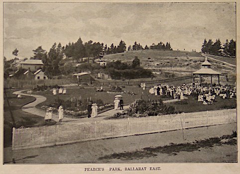
17. Pearce's Park & band rotunda
This was a barren waste before being transformed into a park. In the late 1850s it was mined and was later the site of John Sawyer’s hand-made brickworks. Until the early 20th century it was used as a rubbish dump with a wide drain down the middle. In 1913 it was decided to ‘beautify’ it. A committee of local women under Mrs Hoare, Mrs Stephens and Mrs Ritchie raised the money and worked with the curator of the Ballarat East Town Gardens, Mr Edwards. The women also paid for the band rotunda. The park was named in honour of Cr. Isaiah Pearce, a local resident, benefactor, mining entrepreneur and several times mayor of Ballarat East. It was opened in front of a crowd of several hundred on March 16, 1914. It was regularly used for patriotic gatherings, recruiting meetings, fund-raisers for soldiers and even for an anti-conscription rally. During the deadly ‘flu epidemic of 1919, the Methodist church conducted open air services here. The park became a popular venue popular for fairs, band recitals, community singing, scouting rallies and political meetings.
Pearce's Park c1913 (Source: Ballarat Heritage Services Picture Collection)
.jpg)
18. Shop, corner Barkly & Gladstone Streets
Another early store in Mt Pleasant was the Race Store (pictured), built on the south west corner of the intersection of Barkly and Bradshaw streets. That store was run by James Bennett and his wife Mary Anne. The family owned the store until 1915, and the funeral of the widow Mary Anne left there. Eventually the store was eventually demolished and a brick veneer building was erected on that site.
The Race Store in 1860 (Source: Historical Collection Federation University)
.jpg) 19. Former St Luke's Anglican Church, Gladstone Street
19. Former St Luke's Anglican Church, Gladstone Street
This is the second incarnation of St Luke's. The first version was opened in 1883 as a Mission Chapel in Bond Street nearby. The destruction by fire of the Sunday School in June 1932 may have prompted the decision to relocate around the corner to Gladstone Street. The new church and the Sunday School behind were opened in 1933 but curiously, the church was not consecrated until 1941. From 1980 to 1995 the Sunday School housed St Albans School, the first parish primary school to be opened in Ballarat for 60 years. St Luke's had a marginal but distinctive social role in Mount Pleasant because the Anglicans, unlike the Methodists, allowed dancing. The church was deconsecrated in the mid-1990s. Sadly, it was destroyed by fire on March 21, 2019.
Interior of St Luke's Church in 1947 (Source: Anglican Diocese of Ballarat)
.jpg)
20. 'Clowance', 518 Barkly Street
The house was built for Isaiah Pearce (see stop 17) in 1892-93. Clowance has heritage significance as an intact example of a transitional design between Victorian and Federation styles. It later became a boarding house for women and a maternity hospital run by Sister Simpler who also lived there. While it now lies within Golden Point (the present boundary is contested by older residents), Pearce was historically regarded as a ‘Mount Pleasant person’.
'Clowance' in YEAR (Source: Heritage Council of Victoria)